


Four islands, two people, 1 paddle
(For the amazing video please be sure to scroll to the bottom)
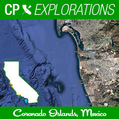
My dad and my Uncle Pierce were both in the military (served in WW2 and the Korean War respectively) and were given the honor of having markers at Fort Rosecrans at Point Loma. For those who have never been there, the views are spectacular. When I go to visit them, one guards me in San Diego bay and the other when I paddle the Pacific Ocean. Both views also lead the eye to the south where there is another country (Mexico) and a few islands that always piqued my curiosity. The Coronado Islands. The legend of these islands includes stories of an old casino during prohibition, military outposts during WW2, smuggling hide-aways, and today, sensitive habitat for bird species and sea-life. So close to us here in the US that you can easily spot them on a clear day, about 10 miles off the shore of Tijuana and Rosarito.

Well, each time I went up there, I stared at these islands, and they stared back. Eventually their presence worked their way into my conversations with my dad and uncle, where I would recap recent adventures, talk about upcoming events with the family, and ask for their support when times were challenging. I started telling them that "one of these days, I am going to paddle around those islands", and I would laugh at what would have been their likely answers. My dad was a cruise ship kind of guy, and would happily have had me take a half day fishing boat to see them up close. My uncle on the other hand, an avid kayaker and naturalist, would probably launch into a long and wonderful description of what I would see when I got there, along the way, and probably throw in some jokes about the line in the movie Treasure of Sierra Madre about "badges, badges, we don't need no stinking badges" as I would be stopped and frisked by locals.
Sometimes these visits were quick, others longer. A few times with the girls alongside me. But the visits always included a glance at those islands. And I swear those islands would look back. Initially inviting me. But more and more it became almost like a challenge. As if the more time went by, the less likely I would do it.
So about 6 months ago, I got to talking about my adventure paddles with a friend named Ty. He expressed interest in paddling some crazy stupid paddles someday, but at that time, was still getting into fighting-weight shape and focusing on coaching duties for his outrigger canoe club. But he offered to escort me with his boat should that ever help make it happen. And the offer stuck. (Stef was much much more comfortable with this setup being international waters etc. and so was I for my first trek there.)

After a few months of planning, finding times of year that worked for very busy schedules and also safest possible conditions, surf and currents, we came up with a several day window. We got together to rehearse loading my oc1 on and off his boat from the water, go over some safety and started the process of hitting "translate" on a ton of websites in Spanish. Because you know, there are various permits, requirements, passports, documents, visas and countless other daunting items that made us question what was really needed or not. In the end, we went to a local fishing bait store (Squidco rocks!!!), picked their brains, purchased various licenses and permits, and were set! The window was narrowed to one specific day, and we headed out early Monday July 26th to see what we could see.
In the days leading up to the launch, I took one last pilgrimage up to the Point/Fort Rosecrans to give a quick heads up to my residents that I was going to make it happen. I had been trying to keep this adventure under wraps a bit, (instead of my usual mass promotion). Too many things could trip it up, and the launch date was not as hard-set set as usual. More of a window. But I did want to let my Uncle and Dad know the plan, and that I was done talking and gonna start doing. Pretty sure they gave me their silent blessings.

The trip itself was fantastic. Ty dropped me and my canoe off 2 miles north of the international border from his boat, "Dina Girl". Originally I was going to launch through the surf in Imperial Beach and rendevu with him, then return to the same location and peel off with me heading to land and him going back to the bay. But some contacts in the Border Patrol and Customs said that would look suspect, not to mention going in and out of surf in an OC1 can always add an extra layer to challenge, even on small days. So instead this was our approach. And it worked great because I would would be able to zig and zag around the islands and head back onto the boat on the return whenever fatigue and laziness dictated. That said, I was determined to log some serious distance miles, so I knew I would not be cheated on that front. And eventually logged a solid 30+ solo miles.

As I was heading south, the islands were in perfect view the whole time. I hit the 5 mile mark of paddling and took my first break (this was my plan to repeat for the day). The islands looked super close now, and I was starting to worry that we dropped my in too far south and that it would be done in fewer miles than warranted the planning and effort. But gosh if those next miles to the first island didn't drag on because the islands were further than I thought. Much like when one races to Catalina, "don't think you are there when you see the island, cus yer not". Not to mention a strong south current had me working way too hard to meet my 5.5mph goal speed.

So at around mile 9.5 I finally got to the south island. And at mile 10 took my second break. We made an effort to avoid any other boats out there, despite all our proper documentation. Was just easier that way. I called over to Ty how close he was comfortable with me getting to the land, he replied "you get as close as you want". So after that break of nutrition, sunscreen stretching and Chamois But'r (if you paddle you get(apply) it), I hugged the island and paddled south along its inland length. With Mexico off to my left, and a ton of fishing aqua culture habitat nets in the distance, the island was a beautiful sight on my right. Tons of birds, the barking of seals, darting Garibaldi underneath me ("Hi Gary!"). An old military outpost up on the hillside, and what looked like ruins from the old casino. Various caves with birds flying in and out of each. Cactus, dirt, cliffs, and water lapping up against the land. This protected site was calm, and allowed me to really take in the views.
As I got to the southern end, as expected the winds and currents started getting a bit more hectic. I circled the tip and started heading north on the exposed side. Bracing against the ricochet from the tall cliffs of the island. We saw some panga boats with fisherman on them using oars to power and steer the boats, and it game me an appreciation for their skills. We crept up north, enjoying a nice bit of current funneling through the islands, and headed west a bit to explore the two smallest islands in the center.
The small center islands revealed a beautiful little protected cove with sea lions, a sea cave, and just really pretty water. We broke from the routine a mile early here for a quick lunch break, at around mile 14. Listening to the sounds, talking about how cool this was etc. After that break, we headed west, out to the furthest and most exposed of the islands, "North Coronado Island" which is the second biggest of the 4. But not before passing the smallest, a white guano covered Matterhorn of land. And the smell to match.

The last island was first seen on the leeward protected side. I decided to go counter clockwise to perimeter this one so the ama would not be exposed to the open ocean swell. But despite this, it was still very rough as the push and flow of the waves bounced up against the island and reverberated right back into me. So I did my best to surf and zig zag a bit. Even Ty was getting bounced around a bunch in his boat. At the end of the exposed side we came alongside the keyhole, where you can look through an archway to the other wise. Once I rounded the island to the protected side again (around this southern tip which again was pretty nuts and had a breaking wave), we stopped at the keyhole again to break, inspect and relax one last time before leaving the islands. This was mile 19 roughly. I felt great, but knew the grind going home would be taxing. So did my best to take my time and enjoy this last time.
We flirted with a sea lion up on the cliff who was extremely curious about us. We waved to Garibaldi fish below, watched various birds play king of the mountain. And Ty clapped loudly to break up a bird fight as there was a small bird getting picked on by a sea gull and Ty was having none of that.
After a nice 20 minutes of working our way casually up the length of the north island, it was time to head home. So with a quick glance around, three islands to my right and behind me, one to my left, I started the mental grind of heading towards the most tiny piece and only land I could make out in the distance that represented the US. The Point Loma headlands. Where all this adventure was first concocted in y brain and in conversation with departed role models long ago.
Fortunately, there was a nice current heading home to counter the onshore ama side wind that was not starting to build. It was still pretty glassy this day, and little by little the islands behind us started to fade away. At around mile 25 some dolphins began to curiously dart and play with us. They would surf Ty's wake, and then dart up ahead to swim upside down underneath me, white belly's exposed, and darting left and right, always ending with a little jump on either side of me. Probably 20 or so dolphins, and this lasted for a good 5 minutes. We were in good hands. Not a coincidence that my fastest speeds of the day took place around this stretch, as my stoke was fueling an otherwise fatigued body.

After the dolphins left, we crossed the international border, and spent another 4 miles aiming for the PL headlands. I contemplated paddling all the way home, which would have been very grueling but doable in these side-wind conditions, but instead decided to call it a day once I got to 30 miles. Ty pulled up alongside and pointed to his wake in cased I wanted to draft him for the last two miles, but I wanted to get in the workout at this point and deal with the mental challenges that come with 6 hours on the water. I embrace that kind of stuff, like a masochist. Weird stuff. But he shares that approach, and understood. So my last mile, I decided to hammer, and get as close as I could to PL. Eventually ending about 5 miles shy, but well beyond the US border and about even with Coronado. We took some time to carefully load the boat, get settled in, and then throttled the boat back to home. Looking back towards the islands a few last times and saying to myself..."boom. did it" and then looking up at the point at Fort Rosecrans where I know I was being watched.
(Thank you Ty, and everyone for all the support and nowledge. Thank you Aqua Adventures for assisting in equipment Garmin GPSMap)
Team Writer Clarke Graves - If there is water, he will paddle it (regardless of craft). Clarke is a surfer turned paddler who grew up in San Diego but has traveled every corner of California enjoying its beauty and appeal. He has had the privilege of racing SUP, OC6, OC2, OC1, Prone, Dragon-boat and surf-ski.
One of Clarke's goals is to paddle as much shoreline in California as he can, with as many paddling friends who are willing to join him. If you have an idea for Clarke to write about or any questions, send it our way and we will pass it along!


Comments