


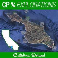
 For many years now, I have wondered what was on the other side. Beyond the little pocket town of Avalon and gates to dirt roads and bison. Far past the waters where the half day fishing boats stop. Catalina Island marked to me a giant body of land begging to be explored by water. I just knew there were coastlines with giant mountains and cliffs, pocket beaches that may not have ever had people walk upon, and of course, crystal clear water teaming with sea life. So when I became friends with Ernie after the Salton Sea Race and the CP Retreat in March, I asked him if he had paddled the islands perimeter since he moved there this past year. And when he answered "no", the next question was immediate...“would you like to?”
It is not often I find a paddle companion willing to take on remote places in canoes. Or tackle 45-55 miles in three days. But Ernie was game, and so we set out to paddle the entire island's coastline. After weeks of planning, and then re-planning as circumstances changed, many maps printed, and asking every local waterman we could about the conditions around the island, we felt we had a good plan in place.
Our original plan had us paddling roughly 15, 18 and 23 miles on each of the days. Avalon to Two Harbors, Two Harbors around the north isthmus back to two harbors, and then finally around the backside and southern tip on day three back to Avalon. However, as often happens with big adventures, things can change. And if there was no other lesson learned this weekend, it would be to adapt, and roll with it to make an adventure happen, no matter what.
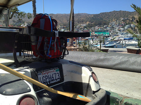
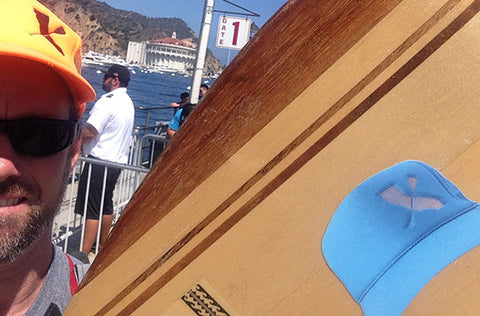
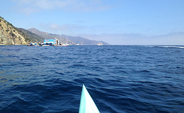
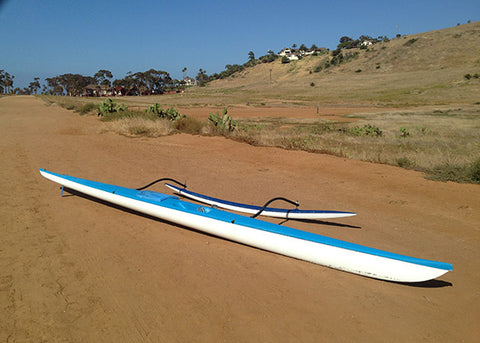
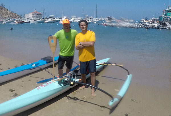
So I came into the ferry terminal Friday morning, and was met by Ernie in his rockin golf cart with a Cali Paddler license plate frame. We revved the engine, and set out to see about our canoes. Originally he was supposed to have a new canoe in hand by this time. But his new Kahe Kai had not yet arrived in Avalon, which forced us to go to plan b. The club he paddles with had an old Seal canoe from a great California shaper Dee Van Winkle on the public racks at Avalon Beach. This combined with a Stingray would be our two steeds. However because we hadn’t counted on the Sea Lion we felt we better give it a sea worthy check first. To make sure it didn’t take on water, and if it did, that it was not too much that couldn’t be accounted for with regular beach stops along the way as needed. The stingray canoe was very familiar with me. Despite being designed in 2003, I have paddled one as my personal oc1 for the last 5 years and consider it my most comfortable and trusted craft, simply because I have logged so many miles on them and understand its nuances very well.
So day one, would need to be a test run instead of heading up to Two Harbors. This was a big of a set back, but proved to be the wise and safe choice. Especially since every mile away from Avalon we went on the water, the harsher the coast line and support for us if needed would become.
Day 1
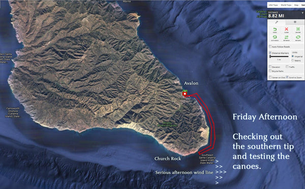
We decided to head south from Avalon and Explore the southern tip. Per several very knowledgeable watermen friends of mine, ranging from fisherman to navy, said the tips of the islands can “get real shitty-real quick”. With wind and current converging from many directions, it is not a place you want to be stuck without proper preparation and training. So knowing this, we decided to get a sniff of what it would be like, and work our way up to it. We went in the afternoon, knowing the winds would be howling on even calm sea days. And we weren’t denied!
Trusting that the canoes we were paddling were holding up well, and knowing there were fishing boats all around as well as my trusty oc-vival kit and marine radio, we headed into the headwind and knew there would be some surf coming home.
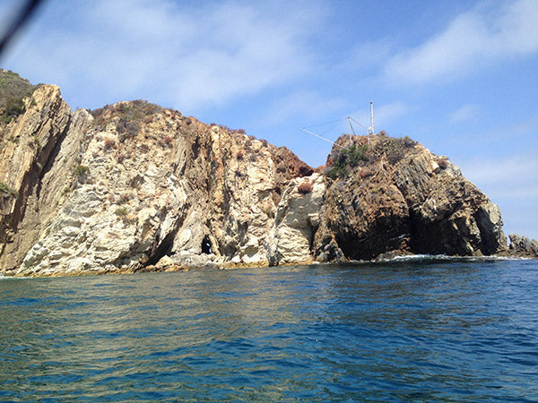
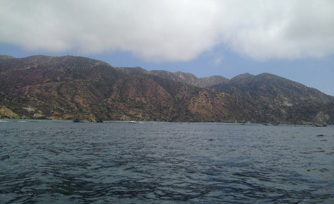
At one point, I asked Ernie what the white stuff was in front of us a few hundred yards. I was looking at a deliniated stretch in front of us that had lines of white, almost like a shallow reef had waves breaking just beyond a calmer patch of water. I had not seen something so different on the water before in two sections. As if someone ran out of blue paint and put a punch of white. Ernie said that it was the “wind line”. Where the lee of the island ended and the water was then exposed to the wind, currents and elements. Hence, the resulting texture. Sure enough, as we got closer, it was apparent. A pretty neat visual sight. We stayed slightly inside of the wind-line hugging the coastline a little bit and continued upwind getting to some huge rocks in the water. We got a ways past Seal Rocks and Church rock was ahead a half mile or so, with incredible head winds doing their best to push us away. We both agreed to not push our luck by going further at this time, and turned around for one of the best oc1 surf sessions I have enjoyed in months. Bump after bump, Ernie and I hooted and hollered as our craft stayed true. Paddles up was the norm for the next 5 minutes as we came back to the eastern side of the island and turned left to get back to the direction of Avalon. It was like these waters had been waiting for a canoe to come surf it! In the lee again of the island, I understood why folks had mentioned the tips could be so tricky. I was grateful we were paddling on a very calm weekend in the summer, and that we had taken the time to get a little bit more familiar with what we might encounter this trip. Feeling more confident in our craft and what we might encounter, we made plans, and contingency plans for the next two days.
Day two
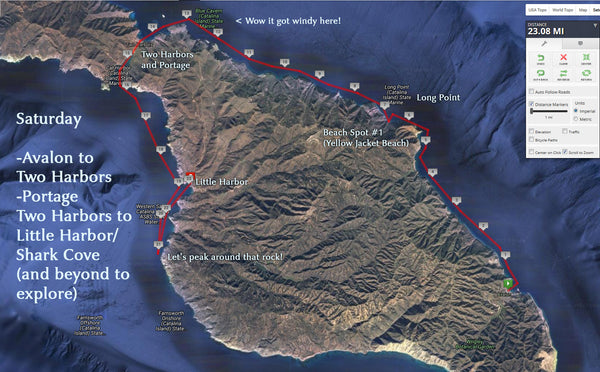
Our plan today was to head from Avalon to Two Harbors and then beyond! Part of what makes paddling around the island a challenge is the logistical planning. We needed to somehow get our gear to where we had reservations to camp, in Little Harbor. We looked up gear haul services, checked with various tour bus companies, and finally came across a friendly face in town that worked for one of the major tourism groups. He was headed to Two Harbors which was a few miles away on the dirt roads, and would leave our bag of camping gear, food and dry clothes at the kiosk at our campground. Feeling that things were falling into place, we were stoked. We got the canoes prepped and loaded with all of the gear and food we would have with us, and pushed off. Northward, to Long Point, the furthest north he had paddled, and then to Two Harbors, the tiny town where awesome races like the Catalina Classic start, eventually finishing at Manhattan Pier. Our Day one Friday paddle was now gong to be our Saturday paddle. With a few extra miles to get down to Little Harbor after a portage. Our excitement had us pushing off from the very crowded sand of Avalon beach with gusto. Leaving the exhaust of idling boats and kids with snorkels in 2 feet of water to the cliffs and pocket beaches I always wanted to see.
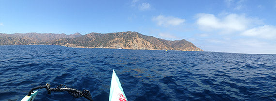
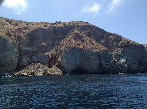
As we headed north, each mile became more remote. There was a little town called Hamilton Cove, then a floating dock for parasailing. Then a beach with a few buildings on it. Each separated by huge towering cliffs. The hillsides on this side were green with coastal sage scrub. We came across the welcome sounds of “hut-hoe” and did a hard right to intersect with Ernie’s teammates at Catalina Outrigger Canoe Club, who were out for a Saturday morning practice. We said hellos and passed along our float plan for the day, and continued to paddle north. The first big land mark was the aforementioned Long Point. The coastline would turn left/west after rounding it so it was our landmark for the first 5 miles or so. Huge jutting peninsula, that stuck out from left to right like a giant finger.
As we got closer I made sure to get close enough to explore. There was a sea cave that went from the south end of the point to the north, and when I rounded it I checked out the other side as well. Decades of shells and rocks, and a few carapaces from lobsters adorned the cave where water was not present.
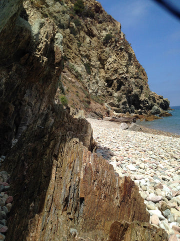
Shortly after we found a pocket beach. Wanting to make sure the canoes were in good shape before going any further, and excited to get some food, we landed on the shore of what we named, “yellow jacket beach” due to all the curious bees that wanted to land on my neon orange hat and our bright jerseys and canoes. They were harmless, and didn’t eat too much of our beef-jerkey so we stayed for 30 minutes or so. The beach was river rocks, so hard to walk on in bare feet. I had brought my flip-flops, Ernie had forgotten his but walks barefoot so much was never too dismayed. It also made the canoe beaching a slow process to make sure we didn’t do any damage as the swells lapped up on the shore. After all, while they were holding up well, they were old and didn’t want our trip to get derailed with a un-reparable ding. The beach had a cool cutout at the base of the 200 foot cliff where remnants of an old campfire were present. Nearby, I made out what would have been a ridiculous trail to climb to get up the cliffs and wondered what would be at the top. But the crashing of the small waves regained my attention, and I felt like I was in one of those moments of zen videos. So I grabbed my camera and did a little 10 second clip to share.
Ernie and I headed back to our canoes, and continued the journey north to Two harbors. Up until now the conditions were glassy and flat. Visibility in the water was 20 feet deep, and Garibaldi fish were almost always spotted when I would look down. Cliffs on the left continued to be bigger and bigger. And the only memorable signs of development now was an old rock quarry. We saw a boat pulled up to the cliffs inside and kids were jumping off a huge rock/cliff probably 30 feet or so into the water. 20 year old me wanted to partake. 40 year old me chuckled at the thought and kept paddling. It was about 2pm now, and Ernie pointed out the landmarks ahead that indicated where we would be turning into Two Harbors. Another mile or two we figured. And then it happened…
Remember earlier when I said I had reliable folks say it could get shitty fast? Well, it did. The conditions went from glassy to windy faster than I imagine. Our clear glassy surface was now a churned up funnel. We had a mile to the turn of a headwind. And while we kept each other close, the wind made talking to each other pretty impossible so we just pushed ahead. By the time we got to the turn to head into Two Harbors, around mile 17 I was getting pretty tired. As we headed now west, there was a ton of boats and activity and civilization again. But wouldn’t you know, the wind was still a head-wind. Now funneling west to east through the Two Harbors valley. Doing its best to keep us at bay. We limped along slowly and finally got to the beach. Passing a marine science research center on the left, and some cool campsites nestled into a small hillside. We beached the vessels, did a check on them and did a little draining as needed. Then went to play hungry tourist and eat a bison burger!
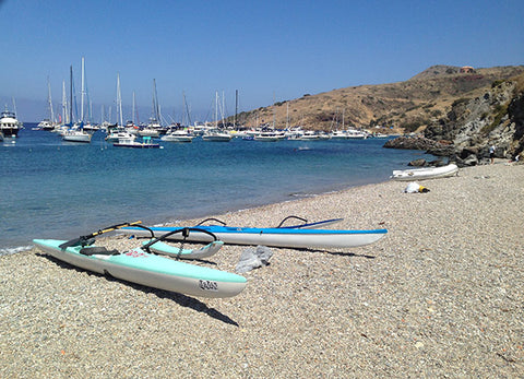
Two harbors is kind of a Margaritaville vibe. Restaurant and bar, outdoor seating everywhere, ice cream stand with 20 minute line to order, and a 70s rock cover band was jamming out for hundreds of tourists. We ate our food, relaxed in the shade and talked about how crazy this many people were here hanging out. Especially since the next and final leg of today’s journey would be into the most remote we had seen. And judging by the wind we just battled, the gnarliest.
After soaking in the final bits of music and food, we began the arduous task of portaging our canoes across the land from the east harbor to the west harbor. Hoofing our canoes and gear down a dirt road with cactus on either side and once again into a headwind, had us getting in our land work for the day. Finally, the canoes were on water again, and we set out to explore the next few miles out of the harbor, into the wild west side of the island, and south to little harbor.
It’s got to be around here somewhere
We expected the conditions to be pretty gnarly at this point, and truthfully paddling out of the harbor was pretty windy, but right when we got to the ocean, the evening glass-off took hold. All the channeling of the afternoon wind subsided. And the fears of the wild wild west were replaced with calm, majestic waters. At least 5 times we both said, “wow, its so calm”.
We had some maps we laminated of the island and referenced before leaving two harbors, but having never paddled here, and all the cliffs being absolutely huge granite walls, we were not sure exactly where the turn in to Little Harbor and Shark Cove (our campsite for the night would be in the crescent shaped stretch of coastline in front of was. We knew it was roughly 3 miles, and could have hugged the coastline, but our weary bodies were convincing us to look ahead at various landmarks and as we paddled aim for them as the most tangent lines. We took turns predicting where the entrance to the harbor fell in the coastline ahead.
Referencing vague memories from the maps about, “I think there was a valley near it” or “I’m pretty sure it had a dirt road leading down to it.” After 40 minutes of paddling, we had a bead on the part of coastline we were searching for, and saw a few boats anchored up in the distance to confirm we had found our campsite! Then, since we had another hour or so of sunlight or so, I posed to Ernie the following… “hey, see that rock way up ahead?” a towering mass in the ocean that had long since separated from the island had been taunting us as the most westward part of the coastline front of us. “Want to paddle to it and just peak around the corner?”

Ernie knew our probable plan the following day would be to retrace our steps and head home in the morning the way we came. After all, the canoes were doing well, but the rest of the island would be so remote etc, it would be a harder route if conditions were sketchy. So he also knew we may never have this chance to be on oc1 canoes and get to get a peak at that stretch that lays just beyond that rock again. So, without hesitation, he said, “yah, I'm up for that”. And so 18 miles became 23 as we paddled the stretch out to the rock past our campsite for the night.
Eagerly anticipating what was around rock, Ernie began taking a more western line to get him a sooner vantage of peaking around the corner. Meanwhile I was hugging the kelp beds inside, watching various birds check me out who hadn’t see a person in a long time I reckon. The coastline was rough. Pocket beaches here and there, but instead of green hillsides, just rock granite and dirt. As if the earth had fallen off into the pacific after years of being hammered by winter swells. Eventually, we both got to the rock…and when we peered around it, expecting to see the furthest stretches of the island 15 miles to the south, we saw… another rock. Just 100 yards further was yet another apex in the islands curvature. And we quickly realized we had been played by Catalina island. Laughing at each other and our unfulfilled expectations, we turned back towards Little Harbor, and feeling the help of some ground swell lifting our canoes all the way home. Despite the teasing of the rock we tried to poke our noses around, the island had gifted us that night with calm conditions, and now a swell to gently send us to our safe harbor. Everything was working out really well.
It’s got to be around here somewhere - Part 2
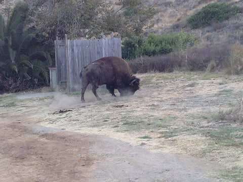
As we entered into harbor, there were 5 or 6 moored boats. The protected cove ended on a mellow beach, and we still had some daylight to find our gear that would be waiting for us, get to our campsite, setup the tent and eat some food. Firewood was purchased upon our original reservation and we were told it would be sitting at our fire ring waiting to be lit. So after we tucked the canoes into bed for the night, (20 yards up on the beach well above any previous kelplines in case we had a fluke tide that night), we ventured into the campground. We must have been quite a site. Campers in their Patagonia vests smiled at us as we wanted around for the entire grounds looking for the ‘kiosk’ that our bag was supposed to be at. We found what we thought was the kiosk, and also some benches. After asking a few campers if anyone had seen a bag sitting near by there or anywhere during the day, we were starting to get a little dismayed. If we weren’t wet and hungry, and now 24 miles of paddling tired, people might have thought we were just making up a story about a missing bag. But our sincere look of gloom was too much to fake. Ernie headed up to our site just in case it was there, I went out to ask another site if they saw our stuff. They directed me to the ranger trailer and gave me his name. As I went to the ranger trailer, I saw not one but two huge bison suddenly beside me on the road. At first I was thinking it was just a brown bush or tree, but it started pawing at the ground and blowing his nose at me so I quickly froze and walked back away. Once a safe distance, I got out my phone and took some video. Temporarily forgetting our current situation of gearlessness, and taken by their size and awesomeness.
To make a long story short, one of the campers I asked soon pulled up in a truck, knew the ranger, and had already radioed him to ask about our gear. Offered us an extra tent, sleeping bags, food and a change of clothes. And anything else we might for the night. He couldn’t believe we had paddled there, and was certain to make sure he helped however he could. His wife and campsite friends drove me up to our site in the back of his truck, and then realized he was co-workers with Ernie when they saw each other.
Catalina is a small island after all!
They had the ranger call around, and found out that our bag was sitting by the benches and kiosks all day, but come evening, one of the tour buses thought it was left behind accidentally and took it into Two Harbors where they thought it was supposed to be, so no one would be ‘left without their gear’. Shortly after the irony settled, we laughed and were told they would be bringing it here via a dirt road in the next hour. In the meantime we had some food from the campers brought up to us and were treated like kings. In fact we ate better than if we had our own gear. And their tent was nicer too :P
Day 3
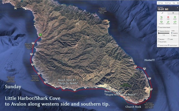
The next morning…after surviving the missing then found gear escapade, I broached Ernie with one more of my “would you be up for…”questions. As mentioned earlier, we were likely going to make this paddle an out and back at this point. But with the mellow conditions the previous night, and the distance not being that much further, we were considering our original plan of making Sunday the major west and southern tip stretch. The canoes had done surprisingly well, and we took good study of the maps and using our phones, google earthed the island to find beaching spots at regular intervals to do equipment checks and rest and reassess. We knew it was in our best interest to get around the islands southern tip before the wind came up per our Friday afternoon knowledge and so the previous day casual paddling would be replaced with a more determined rate. Breaks to chat and dip our feet would be minimal. And we would be racing the day. We also agreed on a turn-around spot to reassess at mile 5 which would let us get home if we had to turn around to two harbors without going beyond 30 miles for the day, and putting us at risk of paddling in the dark. The contingency plan was not needed however. As we found the day before, the west side of the island, while remote, lonely and untouched, was ready to be explored by us!
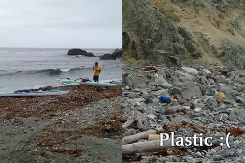
Leaving Little Harbor, there was a sense of exhilaration. We were headed to some pretty cool areas to explore. Checks on the canoes and gear had us feeling safe, and our bodies only whimpered from the previous day of paddling for the first mile or so before they resumed their machine-like cadence. The coastline here was like looking at the moon. There was so much brown and granite coloring in the huge cliffs, that my eyes would play tricks on me of what I thought was a wall, but as I neared it a valley, would appear. The clouds stayed overcast through the morning, and the sun was hidden by the island mountains until late morning. We beached around mile 6 to do a gear check. It looked like a super flat entry from a ¼ mile out, but as we got closer, both of our surfer instincts kicked in and we started evaluating where, and WHEN, we should make our paddle sprint to the beach. Ernie actually caught a swell in that on any other day would have ridden all the way in, but being how critical the canoes and gear was he had on board, he kicked off before he had to, ensuring a smooth landing and canoe lift before the next swell came in. I came in a few minutes later, and he assisted me to get the canoe up the beach beyond the surf line on the river rock beach. I looked around and honestly felt we might have been the first humans to be here. I explored a bit. We named it “kelp-fly beach” due to the insects that thought Ernie’s bright yellow two day paddling jersey was ripe enough to eat! Sadly as I explored, I saw man’s mark had beached itself here. Plastic had been brought ashore in a far corner of the beach, washed up with piles of seaweed, by swells. Man’s impact on this lonely stretch of the island was in fact present. Even if we hadn’t been there directly.
After fueling up on food, and putting a little tape/patch job on the older canoe to make sure the seams along the ama were tight and dry, we pushed off for more exploration. We timed the sets to leave the beach and were headed southward again. This time however, instead of wondering what was around each corner, we had in fact gotten to the diamond tip of the western part of the island, where waaaay off in the distance, we could see what we thought was the southern most tip. We would be staring at it for the next several hours of course…but it was there. So we hoped at least it was the tip.
We had been fooled by the island already, and were quick to temper our confidence and map checks with a willingness to have the tip be even further than we could see.
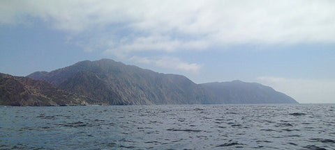
We hadn’t seen another boat for a couple hours, and the beaches were few and fewer. Water met cliffs now, and the canyons were fewer. It really was a moonscape. The sea-life we hoped to see beyond Garibaldi was mostly huge schools of small fish jumping out of the water like flying fish across our canoes as we paddled by. Hundreds of these fish would have us going ooh and ahh for minutes at a time. We had a good speed clip going. The major current was going opposite of us, which kept our speeds down, but we had a ground swell behind us that gave us waves to ride every so often and kept me entertained and I did what I could to catch bumps and get my speed up. If you have seen the movie “UP!” there is a dog who is easily distracted every time he sees a squirrel. That is me with bumps and swell, often losing my direct lines as I chase shiny objects that resemble waves. Ernie on the other hand was not as easily distracted. He would hammer on his line, veering for the sure things but usually keeping his path true. If you were to compare our lines, they always came together every 5-10 minutes or so, but would look a little different in between.
Around mile 11-12 we decided it was prudent to beach again. Check on the canoes, eat and get one last sanity check in before we approached the southern tip of the island. Where the conditions could get hairy, and places to beach might be harder to land on.
So we found a nice pocket to hop in at. Again, from a distance, it looks super mellow. And it might have been, had the slope of the river rock beach not been really really steep! I came in first, and landed the canoe, and proceeded to treacherously get it up the loose river rocks to a flat plateau out of the surf zone. Ernie was right behind me. I had planned to beach mine and quickly get to him and assist but the rocks were ridiculously hard to walk on. They would give way when you stepped on them. Like giant quicksand and with numb feet no fun at all. Needless to say, I only had 20 feet between me and Ernie to travel but it took forever, and a rogue way came before I could get there. Ernie managed to lift the canoe over the wave no problem, but he took the brunt of the force and got a few scrapes on him which will make for great stories down the road. Anyways, we gingerly got the canoe on the beach, Ernie made it up, and we proceeded to eat food, curse ourselves for another, “it looks like an easy beach to land at” moment and name the place, “stupid river rock beach”.
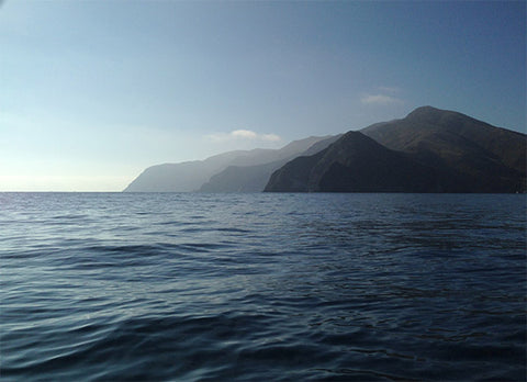
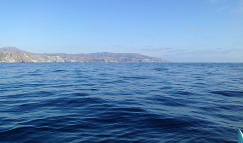
We took our time on this beach, watching the waves and timing the sets. We had made good time to get around the bend at this point and our urgency to get the paddle completed before the wind picked up was countered by our lack of enthusiasm to walk on those blasted rocks any more! That said, made it out safely, and were once again headed south. Knowing our next beaching would likely be at Avalon, 7-9 miles away. Ahead we saw a few miles up what we thought was Church rock. Having seen it two days prior from the other vantage, we weren’t sure it was, but we were cautiously hopeful. We also started see tons of fishing boats on the horizon. Civilization had found us again. No longer were we concerned about not having people nearby should something get sketchy. That said, we also knew those boats didn’t want wind and conditions anymore than we did so we wanted to hurry around the point before conditions changed and our possible ‘friends’ split and headed back to town. But seeing all the boats there, meant to me that conditions were nice up ahead. We looked over our shoulders a bunch as we paddled. Ernie taking GoPro footage of the coastline every so often to document. And me taking my phone out to get picts, always sooo careful when I pulled it from double dry bags to not drop it in the water. This would be the last time we would be seeing the backside of Catalina for quite awhile, perhaps ever for me. I knew once we turned the corner, we’d have the wind. And then the final corner, would mean civilization, rock quarries, buildings and crowds.
So we soaked it in as we paddled. Huge cliffs, clear dark water, embracing the final wonderful feeling of loneliness. And then, just like that, we were at Church Rock. We commented at how literally it didn’t look like a church, but we felt an sense of sanctuary none-the-less. The wind had not gotten crazy yet, but it was starting its howl. We proceeded to watch our speeds pick up .5 mph as we made the turn, and heard seals on nearby rocks barking at us as we went by. The southern apex now was less intimidating. Perhaps because we didn’t battle a headwind to get there. Or because the unknown element we had wondered about was now known. But early Sunday afternoon we breached the final stretch of island, and came up on the eastern side, in the lee of the wind, and had nothing but clear seas ahead of us to get us home.
We took a little time before venturing back to Avalon and did a small swim in the water. It was warm, probably low 70s, and clear. I opened my eyes underwater and enjoyed the turquoise tints dancing all around me. We swapped canoes one final time as we had each time we stopped before, So each of us would carry the heaviest of the gear while the other paddled the older canoe. And noticed a few pieces of trash floating near by that we gathered up and stuffed in our bag. Ahh back to civilization. As we came up on Avalon the sound of boats, and ferry horns drown out our conversation. While we were removed from all of the world, it had apparently continued on without us. Tourists lined the beach, glass bottom boats whipped around Lovers Cove, and para-sailers launched and landed rhythmically. As we beached the canoes, and stood up to stretch a little boy came running up with mud balls he had made and river rocks he found in the sand. Offering them to us proudly. We declined, and said we could do without river rocks anytime soon.
In the end we did 45-50 miles in three days. Due to getting a late start and not wanting to take the unnecessary risk of by paddling in the dark, we didn’t get around the north isthmus. That would have put us at 55 miles for the weekend. Hopefully we can find a way to manage that portion of the island sometime soon, as the views of it from both sides of Two Harbors looked like Na Pali in Kauai. And of course would possibly offer ridiculous water condition challenges. Can’t wait!
So, if you get a chance, we encourage you to explore Catalina. You don’t have to do a perimeter paddle to experience its beauty. Even the Avalon harbor or Two Harbors was amazing. Fish swimming below you, gorgeous cliffs in every direction. And outside of Avalon, never more than a structure or two of buildings, if ever, to dot the hillsides. Untouched California beauty. Just make sure you check the weather first, and have backup plans if you decide to venture out a bit. We sure were glad we did.
Team Writer Clarke Graves - If there is water, he will paddle it (regardless of craft). Clarke is a surfer turned paddler who grew up in San Diego but has traveled every corner of California enjoying its beauty and appeal. He has had the privilege of racing SUP, OC6, OC2, OC1, Prone, Dragon Boat and Surf-ski.
One of Clarke's goals is to paddle as much shoreline in California as he can, with as many paddling friends who are willing to join him. If you have an idea for Clarke to write about or any questions, send it our way and we will pass it along!


Comments