


![]()
This review and support of paddle safety is sponsored by Aqua Adventures. Cali Paddler is very grateful for their role in this review.
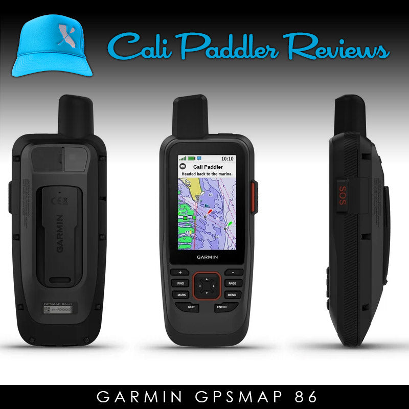
 Safety is not something paddlers always equate with technology. We think of PFDs, leashes, and in some cases the all important marine radio. All of these are important for safe paddling, but there are many dangerous situations that can be helped by a little bit of tech. Introducing the Garmin GPSMAP 86sci and 86i models. A high-end water-ready satellite communication device with GPS tracking, and emergency SOS beacon capabilities. So. Many. Features. We paddled over 90 miles along throughout California across 4 days, day and night, ocean and bay to put it through the test. Enjoy our review.
So, first thing is first. Why would a paddler need carry something like this with them? The answer varies as some features might be important to some, but not others. So please allow me to break down into three categories the main features of this device and how they pertain to paddlers.
inReach® Satellite Communication Device
Want to text your family that you might be late getting off the water? Post a map of your paddle to friends and Facebook that updates every few minutes so your progress can be tracked? How about getting a weather report while staying in a remote location? The GPSMAP 86sci and 86i models (hereby referred to as GPSMAP 86) have the ability to connect to Iridium satellites to send text (custom and preset) messages. It can also be synced via Bluetooth to your phone so you can use that for texting and sending messages while the Garmin is the data transporter device. “But why would I need this if I have a phone?” Glad you asked. You see cell phones are great until they don’t have a signal. Or get wet and stop working. Or lose their charge after a long paddle. But for these scenarios, let’s focus on the first one…not having a signal.
When you paddle out of range of a cell tower, your phone is pretty useless. This may not happen in many bays and harbors, but if you are someone who paddles offshore more than a few miles. Or who explores coastlines outside of big towns or cities, you might find yourself with the dreaded “No Signal” issue. It is real and can happen at the worst time. This Garmin device eliminates that concern as it has inReach® connections (that is what the i stands for in the 86sci or 86i). You are never without the ability to send AND RECEIVE text messages, post your location to people via email/text or social media, and get the latest weather reports. As someone who likes to paddle off the beaten path on lakes, and along rugged coastlines, this reliability not only gives me piece of mind, but my family. Without it, I might not get to take my exploration trips.
GPS Map Tracking
In a previous life I enjoyed running and trail exploration. Maps were cool to check out before, during and after. Well, as a paddler, my adventures now live on the water. And with the GPSMAP 86 I can plot a course, using maps and way-points to know exactly where I am going. And where I currently am. Not to mention how many miles I have gone, speeds and headings. Why would I care about this? Well, on our recent adventure, there was two times it was critically important!
On the first day, we were paddling from Half Moon Bay north to San Francisco. This stretch of Northern California was socked in with fog. And once we turned north at the shipping buoy, we were pretty much out of sight of any land whatsoever for the next two hours. Had we been without the device, we would have come back in, or more likely not even launched. The coastline was too rugged, and too few safe takeout spots to wing it. (Heck, we literally passed by the famous surf reef Mavericks. Don't want to stumped into something there right?) But with the GPSMAP 86 we always had our current location and heading. And it was easy to see our distance from various landmarks. Another cool thing was we pre-planned the trip by tagging various waypoints. This is basically like dropping a pin on your phone map for various locations. We dropped pins at reefs, safe entries, landmarks and points of interest, and of course our finish destination so we could know how far we had to go and what line we had to take to get there (in this case Crissy Field just inside of the Golden Gate Bridge in SF).
{The foggy scene at Half Moon Bay before we headed north to San Francisco.}
At any time that we felt unsure of our heading or location, I simply clicked a button and an icon of me was in the middle of the screen, and maps with way-points overlaid surrounding my location. At one point we each felt we were going the wrong way. My buddy thought we needed to head out more, I thought we needed to veer in more. The device however showed our heading was mostly correct, keeping us from dangerously changing course (technically my friend was more correct in his adjustment suggestion but don’t tell him I said that). A few times we checked and had strayed a bit so we adjusted. After awhile the fog cleared enough to see the coastline and we were less dependent on the device. Except we were not familiar with the coastline and weren’t sure what headlands and mountains and landmarks we should be seeing as our progress markers and finish lines. The device helped with that. It also told us exactly how far off the coast we were. This was important as we knew ahead of time that the winds would shift more onshore by afternoon, and we needed to make sure we were far enough offshore to not get pinned in by reefs. The GPSMAP 86 was invaluable this whole time
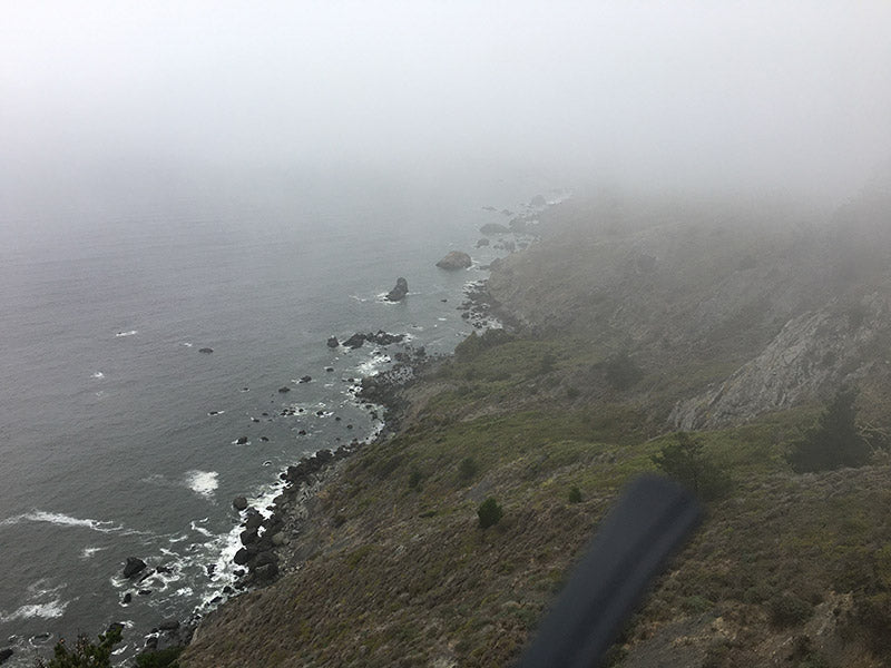
{Looking down from Muir Beach overlook at various sea stacks and hazards to avoid on the paddler later that day. These were added as way-points as hazards so we did not wander in too close to shore. }
A couple days later our course along the Santa Barbara coastline was hampered by a strong headwind and opposing current. What was supposed to be a 3 hour downwind sleigh-ride turned into a 5 hour grind. But the dangerous part was it got dark, and the coastline didn’t have many helpful landmarks that were lit up. So, in addition to bringing glow-sticks and a beacon light, we had the trusty GPSMAP 86 so we could make sure we knew where we were. Be aware of dangers like reefs, rocks, and shipping lanes. And send a nice quick message to our awaiting shuttle crew and family that we were safe and sound, but would be arriving late.
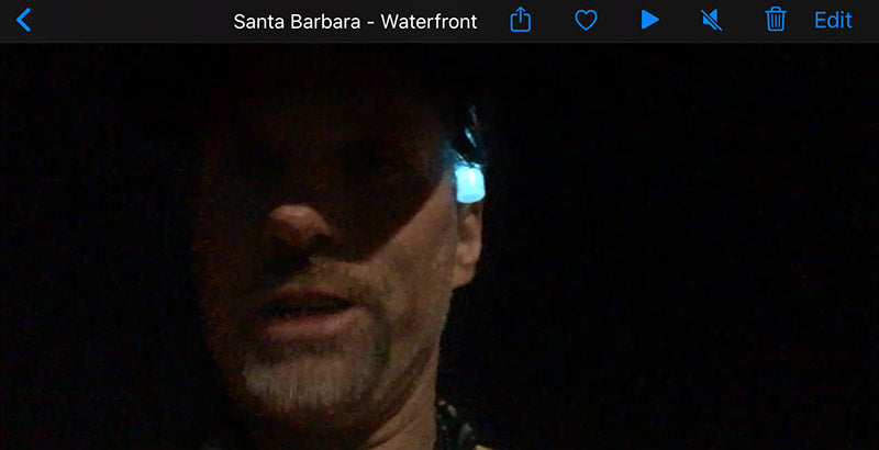
{At the finish of our paddle on day 3. Conditions changed drastically and we ended up finishing in darkness. Having the GPS86 kept us aware at all times of our location and heading, as well as letting loved ones know we were ok despite being late for arrival.
SOS Locator Beacon
So far, the device has helped us stay safe, aware of our location, and in contact with our loved ones if needed. But what about that situation where the paddle poop really hits the fan? Craft malfunction. Injury. Health emergency. Shark attack/whale breach too close. Conditions get too dangerous. I could go on and on. Fortunately on this trip, we did not encounter anything like that, but “what if?” A paddler should be ready for the worst case at all times and hope to never deal with it. So the final feature of this device a paddler would really benefit from is an emergency SOS Personal Locator Beacon (PLB) feature. Flip open a door, press a button for 3 seconds, and then confirm on screen with a final click, and your location will send an emergency distress signal to a first responder network. Coastguard, lifeguard, fire and ambulatory are notified as appropriate of your exact location.
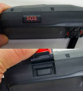
The device requires you to setup an account with your personal info and emergency contacts ahead of time so they know exactly who is calling for assistance. These other devices are sold at marine stores and hiking shops as stand alone units (search for SPOT and PLB) as well as embedded in some fancy handheld marine radios, but this device includes it. I already had a PLB device but would only carry it as a backup now on long solo or adventure paddles. Since this GPSMAP 86 has the capability, and everything else, it is my go-to. My safety, or those around me, is greatly protected knowing that I can send out an SOS signal and help will be on the way.
So those are the main things I found helpful for a paddler.
Pricing, costs and subscriptions...
Ok, I am going to be perfectly honest here. This unit aint’ cheap! Not in the least. The top of the line 86sci I reviewed is $649 MSRP. The 86i is $599. I can’t imagine anyone would just drop that sort of coin without wanting to make sure it is needed. And for many of us, it might not be. If you already have a carry a cellphone, marine radio, personal locator beacon or any combination, you have some important safety capabilities in place. But…and this is a big but…do you have cell signal? Are you near another marine radio person or antenna. Because if you are not in cell signal range, you are basically adrift from a help standpoint with your phone. And you won’t be able to get any map info if you get lost. So, if you are the kind of paddler who ventures into nature, wooded lakes, Columbia river gorge, along remote coastlines, or internationally, you might not have that safety line you so regularly lean on. And you could really regret it.
Finally, there is a monthly subscription you need to pay on top of the cost for the texting inReach® portion. Monthly plans vary from $11.95 to $64.95 based on your needs (# texts, map shares, waypoints etc.) and if you pay month to month or yearly. But you can put it on hold at any time if you don’t need it. So for me, I pay for a month when I know I will be needing those features. Then put on hold, but still have the GPS Map features at all times.
So, base price and the monthly amount, the price tag is not for everyone. that said, to give my family piece of mind is pretty important. And knowing I can help myself or others in a bad spot is pretty valuable too. Our sport is so unpredictable sometimes. It pays to live to tell about it. And if you get creative, you can split the cost with a friend. You just got to make sure you transfer the device on Garmin’s website before big trips to the SOS features are associated with the right person.
Different models and options
I have been talking about the 86sci ($649) and 86i ($599). They are almost the same except the 86sci includes very fancy BlueChart® g3 coastal charts. For another $50 they come preloaded but would cost $150 if purchased separately. With these maps and charts you can see various boat navigation way-points like buoys, harbors, various depths, boat stores, and hazards. Very handy if you are planning to use the map on the water. I found the Basemap land info that came included on the 86sci was totally lacking however. Fortunately there are free OPENMAP solutions that you can download for free and have every street name, Starbucks and trail head you could ever want included. Think of it as the best of both worlds, land and sea. If you don’t want the Sea Charts though, opt for the 86i. Both let you also download BirdsEye® Satellite overlay images for one year after purchase. Anywhere in the world. So it can look like Google earth on the device if you want that instead of maps and elevations.
{The BlueChart G3 maps (shown above on the 86sci) indicate various depths, sea floor terrain, navigational buoys, shipping channels and water related hazards. You can then install other free maps with land based info or just use the Garmin supplied basemap.)
There are two other 86 series options but they do not include the inReach® satellite capabilities, only the mapping. They are the SC ($449) and the S ($399). I do not personally feel they are as important for a paddler, but they are cheaper and if you only need the GPS mapping features, might be worth a look. The entire 86 series also hooks into boating nav sytems, but since I don't have a boat, those were not relevant for this reviewer.
There is also the GPSMAP66 series. These land intended units are very similar but
- Weigh slightly less (8.1oz vs. 9.59oz),
- Are slightly smaller (WxHxD 2.5” x 6.4” x 1.4” vs. 2.65" x 7" x 1.7")
- Do not have a floating design but are still IPX7 water rated (withstands incidental exposure to water of up to 1 meter for up to 30 minutes).
So for me, it was better to get the 86 series. The minimal added size and weight seemed a small hit sacrifice for the floating feature and option to include the sea charts.
The GPSMAP 86 units come with a lanyard, charging cradle and two USB charging cables (one for cradle and one for device). If you want belt clips, carabiners or other connection options they are extra ($9.95 each).
Paddler questions regarding this device...
Can’t I just use my cell phone? It is true, if you paddle in an area with cell signal, then you can call 911, send texts to friends, and even map your location. So rest assured, your phone is still a great device to carry. But as we paddle in remote lakes, rivers or out in the ocean the cell signal can be less reliable. And often non-existent. Then what?
Can’t I just use a marine radio? Marine radios are invaluable for person to person communications and for its emergency channels. But they have a limited range, 6-8 miles for the most powerful, and less for some other radios. Plus you need height and line of site to reach those distances. So, if you are out to sea more than a couple of miles, on a remote section of the coast, you might not be able to contact anyone.
What are situations I might need help?
- Your paddle craft is compromised and you can’t make it home.
- You or a paddle companion is hurt.
- You are lost.
- You are unable to get home due to change in conditions.
Can people track my location when I paddle?
Yes with the inReach service you can start a feature called tracking. You can then send out a text, email or post to social media a link to your activity map. Depending on your plan updates occur every 2 or 10 minutes. When you create your account you can also create a custom url for people to always check out your most recent shared journey.
![]()
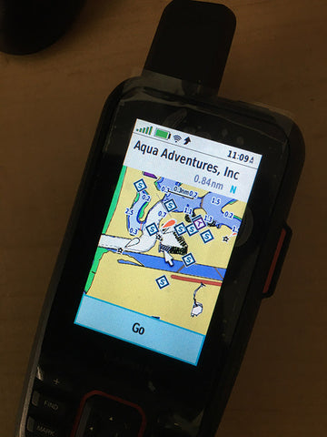
{On day three of our recent testing, we paddled along Santa Barbara coastline. We were able to send an email, text and Facebook post alerting people of the journey so they could track along. The map shows 10 minute intervals with speed and distance covered for each when clicked. View our map at https://share.garmin.com/calipaddler}
Specifications
- Size – 2.65"W x 7"H x 1.7"D (roughly the size of a walkie-talkie or marine radio).
- Weight - 9.59oz
- Features – Emergency beacon. SatComm for texting and sharing your location. GPS maps and location finder.
- Battery Type - rechargeable internal lithium io
- Battery life - up to 40 hours (standard mode); up to 200 hours (expedition mode)
- Memory - 16GB (with microSD card slot for external storage)
- Cost – $600-650
Pros
- Nice colorful 3" (1.5"w x 2.5"H) Sunlight-readable/glare resistant screen.
- Long Battery life. Between 8-30 hours depending on mode and usage.
- Various plan price-points and ability to cancel.
- Can load and enable various maps.
- Waterproof, floats.
- Strobe and beacon light.
- Tons of various apps and settings, too many to list.
- Weather reporting.
- Can be used in non-paddling situations, like hikes, bike rides, off-road, or even trying to find your way to locations in the car with poor cell reception.
- Buttons were easy to use even with numb wet hands. Had tactile feel and click sensation when pressed.
Cons
- Downloading and installing up additional maps was tricky.
- Garmin software eco-system is convoluted. There is the "Explore" App/Website to establish way-points and maps, the "Connect" App/Website to setup your device and download data, and finally the "Basecamp" website to install maps. All together they get the job done but it took me many many hours and nights before I felt ready to push off.
- Typing from the device is cumbersome as it is not a touchscreen. You can link your phone using Bluetooth and then use the explore app to text etc. but my phone isn’t waterproof so it stays in a dry-bag when I paddle.
- Water got into the USB plug area. Didn’t seem to cause any issues but the compartment rubber cover might need to be closed better or something (user error or design flaw?).
- inReach® SatCom and SOS features require monthly service plan. Mapping works regardless however.
Final Summary
This device did not disappoint. You never know when a paddle gets hairy because of fog. Or having to land early in a sketchy spot due weather or travel speeds being slow and the sun setting. All that said, we don’t think this device should compromise your decision making. If it’s not safe, or you have a bad feeling, trust your gut. But it sure is nice being prepared and having a little extra support if you need it in a tough spot. The ability to have a map of your location and way-points, communicate with people back home, track your location, AND SOS emergency beacon abilities makes this a power packed device, supported by a trusted name in the industry, Garmin. Keep an eye out for various sales too. You might score it much cheaper on a Black Friday deal at REI, West Marine or Amazon Prime day.
|
Garmin GPSMAP 86sci |
Garmin GPSMAP 86i |
|
Garmin GPSMAP 86sc |
Garmin GPSMAP 86s |
|
Garmin GPSMAP 66i |
![]() This article is sponsored by Aqua Adventures. Their support of the paddle community continues to inspire, whether you are a on a kayak, sup, outrigger, prone or surf-ski. Visit them at https://www.aqua-adventures.com. And be sure to thank them for supporting paddler safety.
This article is sponsored by Aqua Adventures. Their support of the paddle community continues to inspire, whether you are a on a kayak, sup, outrigger, prone or surf-ski. Visit them at https://www.aqua-adventures.com. And be sure to thank them for supporting paddler safety.
Team Writer Clarke Graves - If there is water, he will paddle it (regardless of craft). Clarke is a surfer turned paddler who grew up in San Diego but has traveled every corner of California enjoying its beauty and appeal. He has had the privilege of racing SUP, OC6, OC2, OC1, Prone, Dragon-boat and surf-ski.
One of Clarke's goals is to paddle as much shoreline in California as he can, with as many paddling friends who are willing to join him. If you have an idea for Clarke to write about or any questions, send it our way and we will pass it along!


Becky Veilleux - July 31, 2023
Hi calipaddler.com webmaster, Great post!
kathy - April 21, 2022
Hi If I get the Garmin 86i can I still download the lakevu maps or do I have to have the 86sci. I will not be using it for open water travels only inland lakes
Thanks in advance for your advice
Kathy