


Sometimes things just line up great.
I am not going to lie, the logistics in planning what I often call adventure paddles can dwarf the paddle effort ten-fold. For this last one I had a local area friend Kristen spend several hours contemplating logistics of safe entries, conditions and timing, hazards and all sorts of things that I needed to bounce off ideas with. Then it was time for more maps. Scouting zoomed in areas, scouring photos taken at different times of years to review surf conditions, tide reports, and historical storm data. Another local friend Di offered encouragement but also some real-talk about the challenges this area would encounter. This caused me to reassess safety and timing…and what I would need to account for in those, worst case scenarios. And then, for this latest adventure a whole new element came into play. It was to traverse a giant military base. Access to the landing spots would require new sorts of logistics and help. Enter another friend Scott who had base access and would sponsor me. As well as scout areas ahead of time since he lived somewhat close, and always was curious about that area. Eyes on the ground they say. And the final thing we had to account for was giant missiles and spacecraft that often get launched from this coastline, resulting in closures of the adjacent seaboard on various dates each year and roaming closures as storms cause changes to flights. This was going to take a lot of planning. Oh, and it would traverse the surf-spot with the highest shark attack rate in the Pacific.

(Scott, shown left, was critically helpful, coming up to the beaches we might land at prior to us coming up. Being our eyes on the ground to ensure we made the best approaches and choices.)
But one thing I can never really lock down with all the planning and accounting…the weather and conditions. I never set out for these adventures to be anything more than calm and easy. I don’t time them for wind and swell (last year Sonoma county being an exception because I was with my friend and crazy-wind-nut John who ‘goes when it blows’). If I have calm and boring and flat, then that is fine by me, as there are plenty of things that can go wrong in the best of conditions (equipment, undersea inhabitants, human failure, etc.).
But alas, weather is only something we can ‘try’ and time. Picking times of year with better visibility. Fewer storms. We can aim to launch in windows that are generally favorable. And then hope we get lucky!

(The Avila2Jalama PaddleX Team: Micah, Scott, Clarke. Vandenberg or Bust!)
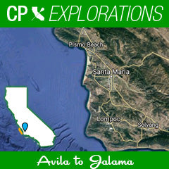
This recent trip would take me from Avila to Jalama. San Luis Obisbo County to Santa Barbara County along giant sand dunes, Point Sal, Vandenberg Air Force Base, around Honda Point and Point Arguello, the site of the largest naval disaster in California history. Landing in a giant exposed sand beach known for huge beach-break waves and wind surfing at a remote camp ground an hour from any other civilization. I was excited. But there was a reason it had taken me this long to make it happen here. As my friend Di wrote in a group email, “this might be the most formidable leg of your California coast passage.”
It felt real.
Now, here is the cool part…timing can sometimes work in our favor. For all the times I have had to cancel a trip, or change plans and faced the disappointment, every so often the stars can align and come up roses. For all the times my easy paddle would turn into a headwind, a rogue set would show up exactly during my entry, or fog would crush any chance to see amazing and much-anticipated landmarks, I had become hardened to the threat of the unknown. As my paddle partner Micah learned, I didn’t celebrate something looking easy until I was back on shore and hoisting up a celebratory beer. Any times before that happened, he would hear me hesitant to reply when he shouted that waves “looked smaller than expected”. Or wind “looked favorable in the wind apps”. I was always the leery one…been burned before, not gonna let my guard down.

(Minuteman Beach - looking south the day before we paddled, we scoped out our landing destination, to try and line up spots that did not have rocks to break our canoes on based on the tide when we would arrive.)
But this trip- the timing was insanely epic and fortuitous! Although when we rolled up on Friday, it was victory at sea with 4 foot waves crashing inconsistently in various places. The wind mixed up on the surface of the ocean so much it looked like a blender had been used. We were to paddle the next day but already wondering if we were going to get a smack down of epic proportions.
Day 1 - Into the Abyss

The following morning, after staying on base in a really sweet cabin on the beach, Scott drove me and Micah up to Avila Fisherman’s Beach at the north end of the bay. This nice protected area allowed us a gentle place to rig and launch. Seeing a sea otter and dozens of seals barking eerily as we paddled out into an abyss of fog. Using three GPS devices to make sure our blind direction was right, as well as looking at maps and landmarks we COULD see, to help guide our initial direction to Point Sal 20 miles away, we set off. We left the break wall comfort and reports had the wind starting pretty early around 8am at 8-12mph from a helpful but not ideal quartering direction. The wind and swell would be pushing us left and we had to surf right. Something we have done plenty of so not foreign, but it requires discipline to not take the fun runners taking us to shore well before out destination. We took breaks each hour as the plan called for. Aim to get 5.5mph speed, doable even with our heavy gear hauls, and take 5 minutes breaks to eat, apply sunscreen, stretch, and check my equipment to make sure still heading in the correct direction.

Early on, something felt off for me. I could never really figure it out but it was not going to be one of my better days. My wetsuit choice quickly proved to be overkill and I was hot. My Vaikobi vest was really tight and impeded taking deep breaths. The canoe felt super heavy. I had no giddy up, and my technique suddenly went to crap. Micah was kind enough to follow pre-planned courtesy of never leaving each other too far away, even though he was obviously feeling strong and catching the groundswell much more effectively than I was. Still though, despite having an off day, I powered on. Around hour 3 I saw a fin to my left, very very close, just beyond my ama. Already on high-alert due to all the shark stories Scott and others had told us over the last few hours, weeks and days, this creature looked small for an adult shark but still had me concerned. It saw me and instead of zig-zagging did a slow 10degree roll and I suddenly thought it might be a sunfish. I paddled away and was telling myself that is what it was…at least until the adventure concluded. After finishing the trip and reviewing pictures of sunfish and shark fins however, I think otherwise. Around 3 and a half hours, there was a flurry of thrashing in the water to our right occupying a big area. We were relieved when we confirmed it was a mega-pod of dolphins. They swam under, around and over us for a couple minutes. Close enough to see their patterning. Close enough to see babies and their moms practically holding flippers. We saw that pod or another again in an hour. It was pretty awesome. And a most welcome animal type to be joining us.
The fog had lifted awhile back and we had the luxury and curse of seeing our next landmark, Point Sal.
The euphoria of seeing a significant landmark and trip milestone usually gives way to despair as you quickly realize an hour later that you still have a long way to go, having stared at it the whole time. I knew this game however and didn’t fall for the mind games of, “I am almost there” emotions. That said, we were grateful to have the visual after paddling into the abyss of fog for several hours. To our left was giant expanses of sand dunes way off in the distance. Our line had taken us about six miles off-shore, but the coastline was not curving in our direction, and I welcomed the proximity.
For those that have read my previous recaps, or spent time on the water, you will know that anytime you come up on a point along the coastline, things can get dicey. Breaking waves. Reverb. Confluence of energy. Unexpected scenarios around the turn. However, much to our glee, this point was looking really chill and relaxed. It is a huge point that sticks out like a hitchhikers thumb. Big mountains, and the start of Vandenberg AF base. The far north east portion was huge sand dunes. Right at the westernmost tip, was seal rock, a snow covered rock that we wanted nothing to do with due to it being a flush with sea life. There were two other rocks around there that were added by me on my GPS from viewing maps. Mostly though we only saw them due to sizeable breaking waves on them and made sure to steer clear. An amazing landmark of the California coastline. And we got to see it from the water’s edge! Rare and special. We did a radio call to land team but did not hear back. We kept heading south, knowing we had another 5 miles to do.
Here is where the wind was supposed to finally line up as we changed course and were heading more easterly. The wind however.had died. Up until now we were thinking of this final stretch as the carrot dangling in front of us. Sleigh rides awaiting.but alas, it would just be a grind for the last stretch. But it was blue skies now and calm glassy seas. Things were great. I reset my GPS for our expected landing spot and we used the previous day’s observations to help us get our bearings on where to aim. “We are heading for the left side of that giant sand area. To the right of where the rock cliffs end” I yelled over to Micah, who was patiently waiting for me after scoring a fun ground swell wave. “Copy that” he replied. He then did another radio check instead of me this time, and hooray we got a response! Scott picked up our call and we learned that he had hurried to this spot due to our quick speeds. My radio was having issues we learned. Having each of us carry a radio had paid off. We spent the next 30 minutes aiming for the beach. Hoping the surf would not be too big and we would make it in safely with him picking the best spot to land and avoid several rock reefs we saw the day before.

(This is our landing spot both days Minuteman Beach. Scott would line up and via VHF radio help guide us in to avoid rocks and big surf).
As we came up on the beach outside the surf, it was so much mellower than the day before. Instead of crazy messy conditions, the peaks were consistent and easy to spot. Not to mention smaller. This day had become a picturesque sunny sky scene. With mellow 2-3 waves and a friend rocking his bright orange cap on the sand waving his arms to guide us to the right spot. Micah went first once we felt we had a good window between sets. He made it mostly in, but got his ama lifted on the inside and went for a minimal swim in the shallows. I slid by him yelling “on your left” to make sure he didn’t flip his ama back over on top of me as I skated by into the sand. He was back in the saddle and finishing his entry pretty quick, and within a minute we were both standing on the beach with Scott giving us high-fives. They day was beautiful. After 5 hours and 25 miles, we had arrived at Minuteman Beach on Vandenberg Air Force Base!

Intermission
After getting our gear loaded and dry clothes put on, we headed north towards Point Sal. To check out a beach the security guard had told Scott about (after talking over who these crazy paddlers were that were heading towards the beach he spotted from binoculars). We drove to Brown beach and posted up at a picnic table, cracked a beer, and stared at beautiful Point Sal, but now from the south. This time not agonizing how it was not getting closer. But instead watching waves crash against it and reliving our day’s adventure with Scott.


Day 2 - Flippin the Script
The plan all along was to head south on day 2. From Minuteman to Jalama, picking up where we beached the day before. However, the wind reports had started to give us major pause on this plan. It was running in a direction that would have made for a major headwind the whole 30 mile route. So for a while I had been contemplating flipping the course. That said, this was a major change and not one I was willing to do flippantly. We had ground swell, current, entry/exit factors to account for. Sure the wind would be better at our backs, but I was not quick to make the call until we kept checking the wind. And checking again. Things change. So we agreed to wait until morning, and be flexible based on safety and best situation.
Come morning, the flipped course still seemed to be the best route based on more current data. In fact, the only fear was the surf at Jalama, which launching through can be treacherous and one bad wave crash could end the trip before it started. I have been coming to Jalama for 15 years. And never seen it gentle or soft. It is a huge beach break, known for amazing camp store hamburgers, crazy wind, and expansive beaches in either directions. To the south Point Conception, Cojo and Hollister Ranch. To the north, Point Arguella and Vandenberg. This site is the only public access in the region and very remote. An hour drive from where we stayed on the base. The windy road finally opening up above our beach below, and wouldn’t you know…our luck of great weather was met with manageable surf! I have never seen it so reasonable in size and must have breathed a big sigh of relief because Scott and Micah looked at me with smiles.

We took our time to rig and feel out the sets coming through from the beach. Picking out spots in between peaks that offered our best chance to paddle without impact. I timed the sets, watched the surfers, and figured out a few indicator spots that would let us know early if a set was coming. I had a spot picked out right in front of the river mouth. And pretty soon, we were standing at the waters edge with our canoes, ready to time the sets and launch. I went first, telling Micah to wait for me to make it out before timing his entry, in case I learned a hard lesson, he could avoid a similar fate. I made it out clean, turned to wave him time his ocean assault shortly after, and we both were ready to begin the day, giving Scott a thumbs up, wave of the neon orange hats, and the day was set to begin.
After the previous day, where I was dragging all day and holding up my wing-man (although he never made me feel bad or slow), I was eager to wash away the stink of my previous struggles, and prove to myself that it was a fluke and I actually had some paddle life in this old body still. I knew within the first stroke it was going to be a great day. My technique was clean, my wardrobe more appropriate having learned a few lessons the day before, and I was throwing down 6.5mph effortlessly and smiling like crazy. Micah and I had our first landmark in site, Point Arguella to the North West, 6 miles away. We talked, paddled, and flew. It was already sunny, and if the wind reports were accurate, we were in for some killer wind conditions in our favor.

The wind apps (we checked three this morning since yesterday we had been a little disappointed in the actual conditions) had said early 8mph heading northwest. Then turning north at 15-18mph, and finishing with 20-25mph north west in early afternoon. And wouldn’t you know…those were the same directions and time-frames of our path! It was as if we cherry picked increases in wind and direction changes to perfectly match every turn we took. It was going to be great! For the meantime though, it was still mild and chill. Perfect to get warmed up and around the two landmarks that have some big history.


Do a google search for shipwreck Point Arguella and Honda Point and you will be blown away. These spots have a literal graveyard of naval tragedies on them. Foul weather, treacherous rocks, unforgiving currents. You know, all the things a couple of OC1s would love to battle. Fortunately for us however, it was simply a relaxed tour of history and geology for us as we toured the cliffs and rocks. At Honda Point we opted to go inside a big rock, which I knew was risky but the chance to paddle over the area and explore was too rare to pass on. I made sure to pay respects to those before me before entering, and was aware of the ghosts all around me. Our presence scared a few hundred huge pelicans on the rock and they suddenly started flight and bombing us with their guano. “Agh that one got my ama” I heard Micah yell, the water turned brown all around us and we dodged the bird doo-doo as well as we could and managed to escape. An underwater rock suddenly appeared with a wave surging over it but we zigged and zagged to safety.
We laughed, counted our blessings and decided to take a break once we were clear of the drama. We stretched, did our routines of various food, sunscreen and stretching. And were noticing that the wind had started to pickup significantly here around mile 8. I tried to drink some water and noticed nothing was coming out. Thinking the hose was pinched, I took out the Camelback bladder from my PFD and found it to be completely empty. I was in disbelief. I had filled it with Micah the night before. Fortunately, Micah packed an extra water bottle and I benefited from his planning. It wasn’t too hot, and the paddle, while long, would not be hard. We would be ok with this setback, and were feeling good. Right then, the voice of god came over our radios. “OK Cali Paddlers, break time is over get paddling!” Our land crew Scott was chiming at us on the vhf radio from cliffs way above. We laughed hysterically at this “busted” moment of relaxing and waved to him up high and radio’d back, “yes sir right away sir” trying to convey our laughter.

(Hard to see us but Scott had binoculars. Here is where he told us that "Break time was over", just north of Hondo Point)
We headed north to some distant landmarks and started to fly. The wind was building, and we started off on what would be the best 20 miles of downwind conditions we could ask for. It started slow, and Micah can surf better than I can (most people can). But it was a great learning opportunity. Conditions that forgave if I made a bad decisions, or missed one, with a follow up wave right behind it. Still not ripping wind, so requiring some skill. But the further we went, the more I learned, improved and found myself in what I like to call the matrix. Everything starts looking like speed ramps. My vision elevated from right in front of me, to 1 wave in front of me. Then 2 waves in front of me. I was predicting the future waves and found myself often side by side with Micah, or matching him just off his right shoulder. Surfing left, then right. Picking peaks, and paddling less and less. This was amazing.

After an hour or so of building speed, we took another break. I had been trying to figure out where exactly we were during the pieces but looking at the pretty scenery often led to missing waves so I battled the desire to look at the coastline and focused on the bumps. This break we were taking was like the others, stretch, eat, sunscreen, drink, talk. Then I realized we were posted up directly off of Surf Beach. This is the only public beach in the area, Vandenberg is bisected by Ocean Blvd that ends at this river-mouth beach. The surf is good but it is famous for sharks. In fact, there is a shark attack on humans every other year (literally) and we were sitting there. While I had mapped this as an emergency landing zone option if we needed one, I quickly pulled my feet out of the water, and started floating down wind and casually urging Micah to get the ball rolling for his break, without explaining why I wanted to get going and risk spooking him as I suddenly was. We got moving sooner than usual and had to have our food digest as we paddled. This ended up hurting Micah as his warm Lunchables and Chips Ahoy cookies didn’t sit right. But despite some dry heaves in the next few miles, he still surfed like a champ.

(Surf Beach - Maybe wasn't the best place to take a lunch break)
We rounded one last land mark around mile 25, Point Purisma. There were some rocks jutting out here and shallow sections. Micah saw a spooky dark thing underwater that turned out to be just a kelp monster. I had seen some birds dive bombing my peripherals that caused water splashes and caught my attention. We were both on high alert, but still surfing our brains out. It was never a top speed crazy event. But it was consistent and constant. Speeds of 7-8mph were the norm. A few 7:45 miles around mile 26 had me hooting like crazy. We had a visual on our landmark 3 miles ahead and all the wind and swell was pointing straight towards it.
It was about mile 27 that Micah yellow out with some urgency, “Did you just see that???” Up ahead on the left he saw something “white and gray and I would say pretty great” flying up out of the water and crashing. I did my best, having not seen it myself, to convince him it was probably just a humpback whale, but “we should start staying side by side from this point forward”. We adjusted our line to avoid the area he saw it, and any ama flying at this point ceased. Whatever it was, we were too close to home to push our luck.
For the last mile, we caught wave after wave right to our landing spot. The waves looked even smaller than the previous day, and while it was windier and messier, it was very welcoming. We both timed some mellow 2-3 foot waves to chase before the next one could catch us, and coasted to shore where Scott was standing at the exact spot with best safe entry. Each of us coasted in with dry hair, and I even let a little wave catch me and push me the last hundred yards in the beach.

Scott helped us carry our canoes to dry sand, we exchanged hugs and congrats. Scott told us he stopped to pickup pizza and beer to celebrate and consume. Did I mention what a great land crew we had??? We spent the next hour getting gear cleaned and loaded up a huge sand dune at the parking lot, taking our time and not rushing. Nowhere to run off to. Just enjoying and soaking up the experience. Staring out at the ferocious white capped ocean that was absolutely ripping and had carried us to the beach. It was probably gusting high 20s at this point. And we scored it. After loading up, and eating some tasty food, we went back to our picnic spot at Brown beach from the day before, to sit, talk, enjoy, and watch birds flying across the sky with the wind heading towards Point Sal.
To give you an idea of how lucky we were with the timing. That night, as we sat on the porch of our cabin. It started to sprinkle. The wind had been the start of a storm circling around. All through the night it would rain, and the next day the wind was onshore, uninviting, and certainly unsafe. The surf had picked up again, easily a good 4-6’. And our window of safe paddling had slammed shut. Almost like a book end for the trip. We arrived it was sketch. We got two days of absolute best weather of the year and conditions to dream about. And then the storm hit and it was Central Coast sketch again. But sometimes…and this trip proved it…things just line up great!

(Our cabin and all the puddles after a night of rain once we finished.)
Thank you to the following for making this trip happen. Kristen for being the first person to help me strategize and make me think this trip could happen. Di Rose for emailing support for yet another crazy Clarke adventure in whatever capacity she could offer, as well as pointing out the seriousness of this coastline and what I should account for. Scott for being an amazing companion willing to help in every way possible to ensure our safety and success, helping land accommodations, base access, missing the second part of his grand-kids soccer game to make sure he was on the coast to get a radio call as we came into vhf range, and driving all around two counties for 3 days in a cramped rav4 full of smelly paddle clothes and day old pizza. And thanks to my wing-man Micah for paddling alongside me on this journey on his first long multi-day trek. It is always special to share these adventures with people open to their uniqueness, but I know it takes a lot of trust in me and my planning. I don’t take it for granted.
Team Writer Clarke Graves - If there is water, he will paddle it (regardless of craft). Clarke is a surfer turned paddler who grew up in San Diego but has traveled every corner of California enjoying its beauty and appeal. He has had the privilege of racing SUP, OC6, OC2, OC1, Prone, Dragon-boat and surf-ski.
One of Clarke's goals is to paddle as much shoreline in California as he can, with as many paddling friends who are willing to join him. If you have an idea for Clarke to write about or any questions, send it our way and we will pass it along!


Cindy - November 15, 2022
I just had the pleasure of reading your account of paddling from Avila to Jalama, really enjoyed it and glad you had such a successful adventure! I’ll be camping at Jalama all next week, one of my favorite places on earth and I’ve often wondered what it would be like to paddle that water… On a good day that is! Glad you guys got one or two. Thank you for sharing!